17 March 2023
Coed Olaf - History of the Farmland
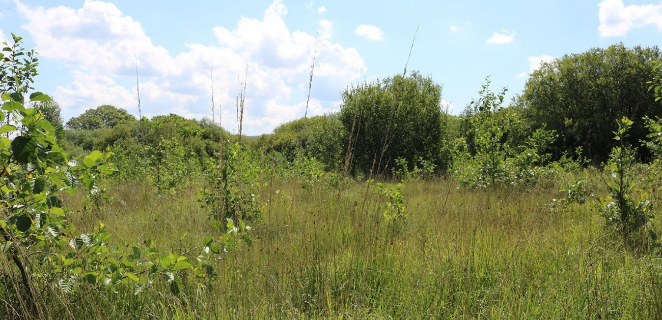
Coed Olaf comprises old, established woods and newly planted wood. The new trees have been planted on former farmland, and here we explain what we know of the farming history of the land.
First and foremost, the landscape at Coed Olaf has been shaped by people and resonates with their patient labour - trees cleared, ditches cut, banks built, streams straightened, fields ploughed, planted and harvested, and cows bred, nurtured, and milked, etc., etc. This is a lived in landscape.
The land was farmed on a small scale (40 – 50 acres per farm) for centuries, but maybe not for millennia; then again, most of Wales has been cultivated at some point in the past. It was always relatively poor land, marginal and low productivity farmland. Most of the fields were wet moorland, called rhôs pasture in South Wales - we will expand on the habitat in a later blog.
The fields to the south were part of Ty-isaf Farm, which is now on the other side of the railway cut in Gwaun-Cae-Gurwen. These fields were farmed as mixed farmland and woodland in the early 19th century. Its field boundaries have an ancient structure, so follow the shape of the land, are concave and flow outwards from Ty-isaf Farm, which seems to extend into the neighbouring farm, Bryn-cethen-bâch, so may have been larger in the distant past. It is unknown how Ty-isaf was farmed in the 20th century, except that it had some pigs in the 1940s; however, it could have been similar to Ty-mawr, a neighbouring farm, i.e., a dairy farm with pigs, hens and horses, with its land a mix of pasture, meadow and wood.
The fields to the north, adjoining Bryncethin Road, belonged to Cwm Garnant Farm, which was originally in Garnant itself and, also, included land in the Amman Valley heading towards Gwaun-Cae-Gurwen. However, with the advent of coalmining and the railways, the farm was reduced in size when the railway line was constructed, and a new farmhouse was built in the early 20th century to the northeast of the woodland. It was a dairy farm (pasture and meadow) in the 1840s, with all the fields in today’s wood, meadow. Unlike Ty-isaf, these fields have a modern shape with straight edges and may have been privately inclosed from moor in the early 19th century.

Whereas the current cowshed is modern (breezeblocks from around the 1960s), a building has been here since at least the 1840s, suggesting this farm was dairy in the early 19th century. The old steading was larger in 1906 and linked to the open drainage system, so the dairy herd could have been larger then. During the mid-20th century, Cwm Garnant was a pig farm, then in the 1980s returned to dairy again.
We can only imagine the stress as other farms became bigger, fields larger, herds larger, farmers investing in new technologies for economies of scale, and farm labour drifting to the cities, while supermarkets pushed prices ever lower. Perhaps to align with this, the two farms were merged in 1983 when a previous owner of Cwm Garnant purchased most of Ty-isaf’s land and specialised the farm on dairy.
Perhaps, this meant that they took on too much debt that was difficult to service, and because everyone in the family had to work on the farm, since most farm labourers had moved away to Cardiff and Swansea, this may have further increased the tension. The consequence was divorce and the land that now comprises the woodland was sold in 1994 but continued to be farmed for dairy on a sale & leaseback arrangement until 2001. However, because of foot & mouth disease, the dairy herd was culled, and the land was likely rented out for sheep farming to new people before being abandoned in c. 2015. It was sold in 2016 and trees were planted.
Agricultural improvement appears to have been basic and limited to open drainage in an attempt to dry the ground, ‘paring and burning’ the peaty topsoil (so-called bietin, hence the name of one of the fields) in some of the fields in Ty-isaf and burning rank vegetation (mainly purple moor grass) in the fields near Bryncethin Road (Waunfain, Waunygarnant). Beyond this, there is no evidence of anything else. Specifically, the low soil fertility (phosphates) gives no hint of any significant use of agrochemicals after the ‘Green Revolution’ of the 1950s; furthermore, soil samples taken in 2022 did not reveal traces of common pesticides or heavy metals, suggesting agrochemical residues may not be present at all.
There may have been limited rotation of the fields in Ty-isaf in the nineteenth and early twentieth centuries: after ‘paring and burning’, perhaps, four ‘white’ crops (barley, oats, wheat and maybe potatoes), then four years pasture, one year fallow, repeat. However, the application of scientific method is unlikely to have been extensive. In contrast, Cwm Garnant was not a mixed farm.
The fields that were ‘pared and burned’ now have depleted topsoil, with no more than 20 cm of thin, dry and unproductive topsoil. Because of the degradation of the topsoil, at some point in the 20th century, these fields became no longer suitable for arable, so were turned over to permanent grassland and mixed rotational farming was stopped. Perhaps, this was when and why the two farms were merged for dairy in the 1980s.
The 1849 Tithes Maps show the field shapes are largely unchanged, except that the larger inclosed fields have been divided into smaller fields, which goes against the trend for small fields to be combined to create bigger, more economically efficient fields. The field names in 1849 were (see map at end of blog):
| Tithes Field Number | Welsh Name | Translation |
| Ty-isaf | Lowest Farmhouse | |
| 223 | Cae Ysgubor | Barn Field |
| 230 | Cae Lloi | Calf Field (Fattening Field?) |
| 229 | Coed Cae | Woodland Field |
| 228 | Cae Newydd | New Field |
| 227 | Cae Newydd Uchaf | Upper New Field |
| 226 | Waungroes | Cross Moor |
| 216 | Waunfach | Small Moor |
| 224 | Cae Mawr | Big Field |
| 225 | Cae Canol | Middle Field |
| 214 | Cae Carkit | Deerwood Field |
| 213 | Woods in Cwmisaf | Woods in Lowest Valley |
| 215 | Cae Biettin | Pared and Burned Field |
| Cwm Garnant | Garnant Valley | |
| 210 (Only the wood) | Field (Pasture & Wood) | Field (Pasture & Wood) |
| 367 | Waunygarnant | Garnant Moor |
| 368 | Waunfain | Narrow Moor |
Most of the land was then, like now, wet moorland; waun or gwaun means moor, moorland field or wet meadow. In the 1840s, 91% of the land was farmed. 4 of the fields (9 modern compartments) were moor, comprising 26 acres or 53%. The better fields were recorded as cae, i.e., fields, and were 20 acres or 38%. The remaining 9% was wood.
About 2015, the land was sheep grazing, and woods had doubled to about 18% of the farmland, with the remaining 82% grassland split 50% to moor and 32% to meadow. Now, because of the unprofitability of this type of farmland, almost all the land has been given over to wood, with new trees planted in many of the fields.