22 February 2023
Summary: Geography Of The Old North
Summary of the suggested place names for the poems of Taliesin, Aneirin and Nennius' battles of Arthur, giving new settings for Rheged and Goddeu.
An overview of main places in Rheged, Taliesin, Aneirin and Arthur’s battles (Nennius):
| Names in Taliesin, Aneirin, Nennius | Axel’s Location – Main | Axel’s Location – Alternative |
| Aeron | Aire – Airedale | |
| Arfynydd | Confluence of Leven and Tees | Yarm (Y Ar Fynydd) |
| Argoed, Argoed Llwyfain, Kaer Nefenhir, Silva Celidonis, Coit Celidon | The Forest on the Leven, Kirklevington-Castlelevington | |
| Arthur (Ar Dwr) | Echwydd, Rheged | |
| Rhag Eidyn (Eidyn Hill), Monte Badonis | Roseberry Topping | Is this where Castle Eden is? |
| Brynaich | Bernicia | |
| Catraeth | Sandbanks on Swale at Catterick | Catterick |
| Defwy, Deifr | Derwent, Yorkshire | Derwent, County Durham |
| Deiron | Deira | |
| Derwennydd waterfall | Wharnley Burn Waterfall, Castleside | |
| Dubglas (Douglas) | The Humber | |
| Eidyn, Caer Eidyn, Ddin Eidyn, Campodonum (Bede) | Castle Eden, Teesside | Citadel at Roseberry Topping |
| Eirch | Ouse - Arkendale | Arkle Beck - Arkengarthdale |
| Elmet | West Yorkshire | Airedale |
| Erechwydd, Monte Agned, Oppido Municipalis (Bede) | Aldborough, Burrough Hill in Aldborough | |
| Gafran | Garforth | |
| River Glein | Swale (Catraeth) | Glen, Northumberland (Yeavering Bell) |
| Goddeu, Gododdin | Teesside | Area around Roseberry Topping |
| Fort Guinnion | York (Eboracum) | |
| Gwen Ystrad | Wensleydale | Catterick fort |
| Gwynedd | Gwynedd (connected by birth to Gododdin) | |
| Idon, River Bassas, Dunum Sinus | Tees or Leven, which flows from Roseberry Topping (Eidyn Hill), but maybe only the tidal/navigable part | Castle Eden Beck |
| Lleenawg, Llan Llenawg | Linton, near Wetherby | |
| Llech Wen | Whitestone Cliff | Catterick |
| Lloegr | Anglo-Saxons (English) - the enemy! | |
| Llwyfennydd, Celidon | Area around the river Leven, North Yorkshire – Castlelevington | |
| Manaw, Manawyd | Plain of Holderness | Goodmanham; Roseberry Topping |
| Pencoed, Penprys | Elmet Wood, Silva Elmete | |
| Prydyn | Picts | |
| Rheged, Rheithfyw | Ryedale (Rievaulx) | |
| Tribuit | Wear | The Wear at Durham |
A rough sketch of the Old North:
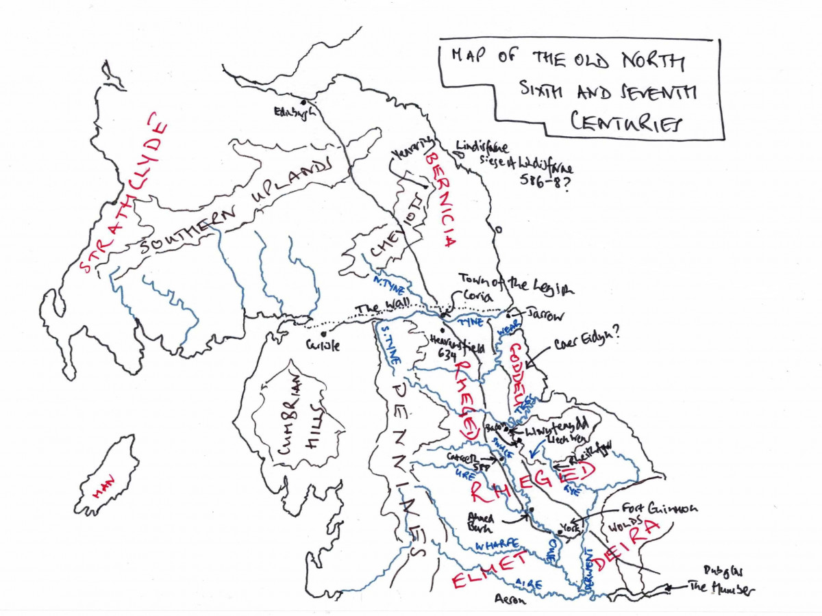
As my thoughts are very different from the standard, I thought it sensible to imagine the landscape as in the sixth century:
To the north, in north Northumbria, between the Wall and the Tweed, the Bernician Anglo-Saxons (Brynaich) held the territory. They were based at Yeavering Bell, Bamburgh and Holy Island, and their territory may have stretched down to Newcastle, the Pons Aelius of Roman Britain, because Newcastle and the Tyne are conspicuously absent from mentions about Rheged. To the southeast, the Anglo-Saxons (Deiron) were confined to the Plain of Holderness (Manaw) in the marshy plain above the Humber and which stretched from Spurn Head to the Yorkshire Wolds. The Humberside Anglo-Saxons’ region is Deira and called Manaw by Rheged. South of the Humber, the realm was Lindsey and generally falls outside of this narrative landscape.
Further northwest, the kingdom of Strathclyde was based around Dumbarton and stretched south and maybe east towards Lothian. Further west, there was Powys that maps around north-central Wales, stretching from Wroxeter towards the Cheshire Plain and perhaps east to the Pennines. Beyond Powys in northwest Wales, there was the Romano-British kingdom of Gwynedd, with which Rheged is allied, because their leadership is connected through their maternal line to Gododdin and would later expand to become the dominant realm in Wales. There is a gap in this geography for the Cumbrian region around Carlisle.
These are the areas that define the places outside of Rheged’s direct sphere of influence.
Standing in Ahned, surveying the landscape from Burgh Hill, Taliesin visualizes Urien’s Rheged. It stretches from where the Ouse (Eirch) flows into the Humber to York, north along the edges of the Wolds past Malton into the Vale of Pickering and the rivers Derwent and Rye to the Cleveland Hills and North York Moors, where Rievaulx or Ryedale lies, and from there to the sea. From York, the realm goes west as far as the river Aire (Aeron) and then goes north along the edge of the Pennines towards Catterick and the river Swale.
At the centre of this dale of Wensleydale (Gwen Ystrad) or the Vale or York lies Erechwydd, the Romano-British settlement of Isurium, which is the urbs regia of the region and the local ruler, Urien of Rheged. The Roman road goes from York through Ahned to Catterick (Catraeth) and then north to Piercebridge and at its end is Coria, where the legion used to be based and is the northern limit of Rheged and finished at the Wall near Stagshaw or Matfen. From Burgh Hill, Taliesin can see the white hills and Whitestone Cliff (Llech Wen) to the northeast and east he can see the Pennines and these seem to arc round towards the Cleveland Hills, where a small gap opens to the Leven valley.
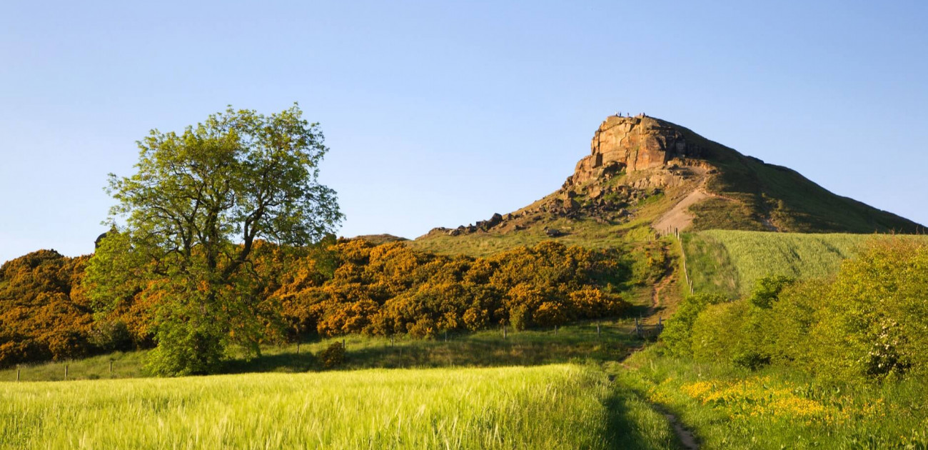
Visiting the Leven valley (Llwyfennydd) on another day, Taliesin rides along the northern border of Urien’s Rheged. From the top of Roseberry Topping, Taliesin can see how the Cleveland Hills forms a natural border alongside the Tees as it flows out to the North Sea. The Leven starts on Roseberry Topping then flows through the fertile and farmed valley towards Yarm, where it joins the Tees. There is a flat plain between the Tees at Yarm, the Leven towards Castlelevington and the forest that lies between here at Whitestone Cliff and runs along the edge of the Cod Beck. Boats can be seen on the Tees at Yarm where they unload goods and produce that come as far up the Tees as they can, including the lovely red wine from the continent. On a fine day like today, you can see down along the Leven past Yarm to Catterick not that far away to the west.
On the northern side of the Tees, there is the lordship of Gododdin which forms part of Rheged but is outside the day-to-day control of Urien. The plain stretches from the Idon estuary which is what the tidal stretch of the river Tees is called after Yarm (Arfynydd) , and the Romans called Dunum Sinus. The centre of this lordship is Castle Eden (Ddin Eidyn), the old Roman villa of Campodonum. Aneirin is the bard here, a good friend of Taliesin. The northern edge of Gododdin is the river Wear and, along Dere Street towards Coria, there flows the river Derwent in a steep dale midway between Piercebridge and Coria. North of the Wear, the land around the tidal estuary of the Tyne near Pons Aelius is controlled by the Bernician Anglo-Saxons, so the Tees is the safest route to the sea for Rheged, because the Humber risks being attacked by the Deiran settlers in the Plain of Holderness.
Essentially, Rheged was the northern section of the Eastern Plain that forms an arc from Teesside to Norfolk.
To the southwest of Rheged, beyond the Aire, there is Gwallawg’s realm of Elmet that stretches from Linton to Elmet Wood, which is below the Pennines in the east, and then in the south is bounded by the boggy fenland that becomes Lindsey. Gwallawg is a good friend to Urien and Rheged, allying with them to hold back the Anglo-Saxons.