01 May 2023
Nennius and Arthur's Battles Revisited: A Map of The Old North
Earlier, I wrote a first cut of a possible solution to Nennius' battles of Arthur. Here, I update that blog, correcting a mistake and firming up the reasoning, but it still places Rheged in the North between the Don and the Tyne.
When I first relooked at Arthur’s battles in Nennius’ British History, I had an inkling that there may be a different interpretation of the passage on Arthur’s twelve battles. I made some mistakes but the general sense was good.
In essence, I undertook a thought experiment as to whether the Latin could be treated as a word puzzle, so rather than Arthur’s battles being seen as places to be found in themselves, they were clues to the names of places, which then could be found. So, I challenged myself whether it could be an indirect set of locations and not a direct list of places and while I expect that there are better resolutions, I think the theory is sound.
Indeed, the more I have researched it, the clearer my rationale has become, particularly after I realised that I had made a mistake with my solution for Agned Hill which was clearly wrong, so sorry about that. I have divided this blog into four sections: the first is a table of the locations; the second is an explanation of how I have solved each clue; the third is a possible explanation of what the passage means; finally, I give a version of the Latin and my translations of it.
Table of Arthur’s Battles
| Battle | Nennius' Latin | Translation | Location (alternatives) |
| 1 | Flumen Glein | River Glein | River Swale |
| 2 - 5 | Flumen Dubglas | River Dubglas | The Humber |
| 6 | Flumen Bassas | River Bassas | River Ure |
| 7 | Silva Celidonis | Celyddon Forest | The Forest, Kirklevington |
| 8 | Castello Guinnion | Guinnion Fort | York |
| 9 | Urbe Legionis | City of the Legion | Corbridge |
| 10 | Flumen Tribuit | River Tribuit | River Wear |
| 11 | Monte Agned | Agned Hill | Sedbury Hill |
| 11 (b) | Cat Bregion | Battle of Brewyn | Sedbury Hill |
| 12 | Monte Badonis | Badon Hill | Roseberry Topping |
| Gueith Camlann | Battle of Camlann | Castlesteads (or Birdoswald) |
Most places are in North Yorkshire, between the Humber and the Tees. The exceptions are Corbridge, which is in Northumberland, and the River Wear, which is in County Durham and Tyne & Wear. All, though, are in the sphere of influence of the Northeast.
An Explanation of the ‘Battle’ Locations
Battle 1: Mouth of the River Glein. Glyn is Brittonic for a glen or dale (4), which in Latin is valles. If you shift the ‘s’ to the start of the word, you get ‘svalle’, which is the Swale. The mouth of the Swale is at its confluence with the Ure at Myton-on-Swale, slightly east of Aldborough. There was a battle here in 1319 between the Scots under Robert the Bruce and the English, where the English were totally defeated, suffering significant losses compared to the very light casualties of the Scots.
Battles 2 – 5: Four battles on the river Dubglas or Douglas next to the region of Lindsey. Dub-glas means dark or shadow watercourse in Brittonic (4). Shadow is umbra in Latin, so the Dubglas is the Humber, which is next to Lindsey, now known as Lincolnshire. The four battles are perhaps the four rivers in this region which are the rivers Don, Went, Aire and Wharfe. Alternatively, it could mean the river Trent instead of one of the others, but I think it is the rivers that I have mentioned. If they must be locations, then they could be where the main road from Lincoln to York crosses these rivers, so somewhere southwest of Doncaster around Hatfield Chase, Thorpe Audlin to the west of Wentbridge, Castleford, and Tadcaster, respectively. These have been the scenes for battles over the years, e.g., the battle of Hatfield Chase (633) and the battle of the Uinued (655) (1).
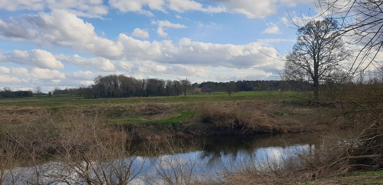
Battle 6: River Bassas. Bassas or bassus is basis in Latin, which is foundation or origin, or ur. Ur has the sense of original, primitive or earliest, e.g., the German for origin is urkunft and ursprung. This is the river Ure (as in the picture above). The Ure becomes the Ouse at Thorpe Underwood when the Ouse Gill Beck joins it and downstream flows into the Humber estuary, but historically it may have become the Ouse at the confluence of the Swale and Ure at Myton, i.e., at Battle 1.
Battle 7: The battle at Silva Celidonis which is called Cat Coit Celidon. This is Taliesin’s Gweith Argoet Llwyfain or the battle located between Kirklevington and Yarm, between the Forest and the Leven and Tees rivers. I have discussed this in a previous blog but will provide a corrected blog, together with better detail, but this may take some time as it is a tricky subject.
Battle 8: Castello Guinnion. Castello Guinnion means the White Fortress, where castello is castle or fortress and Guinnion comes from guinn, gwen or gwyn which means pale, fair, white in Brittonic, hence the White Fortress (4). However, you need to add the gloss to this: ‘Arthur carried the image of Holy Mary, the everlasting Virgin, on his shoulders and the heathens were put to flight on that day, and there was a great slaughter upon them, through the power of Our Lord Jesus Christ and the power of the Holy Virgin Mary, His mother.’ This crossword-style clue is a four-letter word and so is an icon. Reverting to Guinnion, this means white or ivory here, so is ebor. We get Ebor + Icon, which is Eboracum, or York.
Battle 9: Urbe Legionis. Urbe Legionis translates as City or Town of The Legion. This is Coria or Corstopitum, the modern Corbridge. After AD 160, it was a base for legionaries with known links to the Twentieth Legion (Legio XX Valeria Victrix, whose main base was at Chester) and the Sixth Legion (Legio VI Victrix from York), and Corbridge was labelled ‘Town of the Cohort’ or ‘Cohortis Oppidum’ in Francis Stukeley’s map of the Antonine Itinerary, dated 1723. The riddle is unpacked as follows: Urbe Legionis is the City or Town of the Legion, Host or Battalion, so becomes Coria Oppidum where oppidum is Latin for Town and corjo in Celtic, coria in Brittonic and coord in Welsh means a host or contingent of soldiers (4). Coria Oppidum then reduces to Corstopitum, one of the names for Corbridge Roman town, or simply Coria. Coria’s deep meaning is found in other placenames, e.g., Tricurius, which was in Cornwall, and Petrucorii in France and mean ‘three battalions’ and ‘four battalions’ respectively; these are preserved in the Hundred of Trigg, Périgueux and Périgord (3). There have been battles in this area, e.g., Cadwallon killed Eanfrith here (634), the battle of Heavenfield (634) was fought between Corbridge and Devil’s Water to the southwest, and two Viking battles in 913/15 and 918. Despite this, I think the derivation of Corbridge may really be from the Brittonic cors which means fen or marshland. The Cor Burn’s watershed is in the fens around Shildon Bog and northeast near Matfen and Fenwick, so the cor element in the placename may predate the Romans and be a happy coincidence of words, i.e., of cors and coria.
Battle 10: Bank of the river Tribuit. Tri means three and perhaps can have the sense of many (4). Buit or būyδ is the Brittonic verbal noun meaning a bend (4). Another word for bend or curved is wejr. So, the river Tribuit is the Wear. It may be more specific and refer to Caer Weir which was perhaps located roughly where Durham Cathedral is now, because here the River Wear bends three times to enclose the rock on which the cathedral was built later. There is a political logic to build your new cathedral over an old Roman and British seat of power, which both conquers the old site and at the same time links you back to the old seat of local power. In Armes Prydein Vawr, Caer Weir was considered far away but it was a known place, mentally if not also physically, so you have ‘Gwaethyl gwyr hyt Gaer Weir gwasgarawt allmyn’, which translates as ‘The warriors will scatter the foreigners as far as Caer Weir,’ where the foreigners are the Anglo-Saxons, or Lloegr, the Germanic invaders.
Battle 11: Agned Hill. Agned derives from the Brittonic anhed that means settlement or dwelling place. The Indo-European root is sed- that means a settlement, which is sedes in Latin. This is Sedbury Hill at Scotch Corner, which is a slight hill but has a commanding view of the Vale of York and is a junction to the North, West and East. Linguistically Sedbury derives from sed and burg, so is 'settlement hill hill'. Archaeological evidence has a British settlement here before the Romans and then during the Roman period, with close connections to the huge Brigantes settlement nearby at Stanwick. Its alternate name seems to have been Breguoin Hill or White Hill, because it is a limestone hill. This location is explained by the line in one of Taliesin's poems: 'kat gellawr brewyn'. This translates as 'fighting near Gilling [West] at Sedbury Hill'. Gilling is the name of the local wapentakes and was called 'Ghellinges' in Domesday, so if Sedbury Hill is alternately Brewyn-Breguoin, then it was close to Gilling Beck which flows to its south and the village of Gilling is only a mile or so away. Gilling was in Gilling West and Sedbury in Gilling East wapentakes, with the beck being the dividing line. Just to be clear, the hill was unlikely ever called Monte Agned or Ahned Hill, because like most of the names in this paragraph of Nennius' history, they are riddles rather than the actual name; nevertheless, the alternate name Breguoin for Sedbury does appear to be the right name, which was the purpose of the revision.
12: Badon Hill. Traditionally, Badon has been identified with Bath, but Bath is on the level floodplain of the Avon, though there are fells around it, and Badon is written down with only a voiced single stop ‘d’ in the different manuscripts, whereas a bath is ‘baddon’ with the voiced fricative ‘dd’ having the sound ‘th’. So, Gildas, Nennius and the Welsh Annals all record it as Badon not Baddon, or Latinized variations of this, and always with the single ‘d’. Andrew Breeze gets round this by suggesting that the scribe miswrote ‘the obscure and meaningless Badon’ in all these places for Braydon Hill (1), but I think the scribes did not make mistakes so there is no need to correct them. So, Badon is identifiable as Roseberry Topping. Firstly, the hill is first recorded as Othenesberg in 1119, which can easily be understood as developing from something that sounded like Bodenes + Berg, hence Monte Badonis or Badon Hill. Secondly, the area around Howe Hill just to the west near Seamer has been associated with the battle of Badon Hill since at least Holinshed in the sixteenth century. Thirdly, I think the old name for the hill was Langbargh which would have been the Germanic development from the Brittonic Long Berg, or perhaps Long Brigant, where longa is a boat in Brittonic, llong in Welsh and derives from the Latin navis longa. Lang is the Old English for long as in length, so it is easy to see how this morphed from Brittonic long into the Old English lang. A boat in Welsh is bad, so the hill of the boat in a mix of Latin and Brittonic becomes Monte/Mons Badonis or Monte/Mons Longis. The question is how do I justify my claim? Today, if you walk up Roseberry Topping you park at Great Ayton, but, in the past, you may have come from the hamlet of Langbaurgh and then perhaps walked to Langbaurgh Ridge and then walked up Roseberry Topping that way, as the ridge connects to the fell. However, it seems strange to call a ridge ‘the long hill ridge’ unless it was a ridge that connected to a hill that was called long hill, i.e., Langbaurgh, and this is the hill beside it, which is now called Roseberry Topping. Furthermore, the only two hills noted on Blaeu Atlas Maior from the 1620s are Freburg Hill (Battle 11) and Toppin Hill, and these are both in the Langbargh wapentake and Langbaurgh is the historic meeting place of this wapentake. It seems strange to call a very large wapentake that includes much of Cleveland with a smattering of farms and a ridge unless it was, also, the name of the principal hill in the region, which once again takes us to Toppin Hill, or Roseberry Topping, so the meeting place was likely beneath the well-known landmark of Langbaurgh Hill. Therefore, the former Brittonic name seems to have been Lang Berg, or Long Hill, which translates to Boat Hill or Monte Badonis.
There are two other battles associated with Arthur: an alternative version of battle 11 (the so-called Vatican Recension) is at Breguoin and I've incorporated into the texts at the end of this blog; Arthur’s death at Camlann in the Cambrian Annals. Andrew Breeze explains these as being Bremenium, which is at Rochester in Northumberland, and Camboglanna, which is now thought to be Castlesteads but could be Birdoswald (1). The first is on Dere Street going northwards from the Wall, and Castlesteads and Birdoswald are on the Wall in Cumbria. I do not have any particular issues Camlann as Brememium, but for me Breguoin is just another name for Ahned, so is also Sedbury at Scotch Corner. The bre has the sense of hill or burg/brough and and (g)uoin is likely gwen and so fair or white - this may be explained by its geology which is limestone or that it is on Gwen Ystrat.
Some Thoughts
For a summary of the mainstream of ideas on the places in Nennius’ Historia Brittonum, the best are two essays by Andrew Breeze, which I cite at the end of this blog.
As for Arthur, in Historia Brittonum, Arthur is a narrative device to present a riddle. Maybe, Arthur had a deeper meaning for the British, but I do not think he is being described as a single person or perhaps a specific person in this instance; Arthur may be a word that has the sense of Rheged or a heidsman, but I don’t really have any idea what the rationale could be and am unconvinced by pretty much everything I have read on it. Indeed, because of his wispy shape and as he is recorded in Annales Cambriae, he could become a legend precisely because his character is so plastic, but because legends attached to his persona so strongly, he must speak to something deep within the British psyche. Arthur may be an historic person, perhaps Ambrosius Aurelianus, and, if so, he could have fought at Badon in 493 and then could have died at the battle of Camlann in 437. What is clear, though, is that because the two (or three) likely battles described in this passage were fought a long way apart in time, they cannot be about one person.
Whereas most of the locations in the History are not physical battlefields but geographic points, two (or three) may be actual battles, because these are the only two recorded directly with their names rather than indirectly via a crossword clue and are, also, recorded in other literature. They are:
- Monte Badonis (Roseberry Topping) (Battle 12): As well as in Nennius’ History, the siege of Mount Badon (obsessionis Badonici montis), the twelfth battle, is recorded by Gildas in ‘The Ruin of Britain’ and as the battle of Badonis in the Annales Cambriae. The dates differ but Andrew Breeze argues that the battle of Mons Badonicus was in 493, which agrees with the date that Bede recorded (1). Further, Breeze has the battle fought by Ambrosius Aurelianus, who is the military leader implied in Gildas’ ‘The Ruin of Britain’.
- Cat Coed Celidon (The Forest at Kirk Levington) (Battle 7): This is the battle fought by Urien and Owain perhaps against against Theodoric, leader of Bernicia, where the Britons defeated the Saxons on the plain by the Tees. This battle was likely in the mid to late 580s, because Urien died c. 588. So, Urien is the military chieftain in this battle and it was about a century later than Monte Badonis. I think that the battle of Breguoin may, also, be in Cleveland, and was fought by Urien at Langbaurgh Ridge sometime prior to Cat Coed Celidon.
The questions are what is the relevance of this passage, what is it trying to tell us? Firstly, it is not giving us details about Arthur, or an Arthur, because there are at least two time periods, so, were it about a person, it would be about the deeds of at least two persons not one.
Secondly, whereas they are not battles except for the two or three discussed above, they do appear to be describing a geography. These are hills that are points within the landscape and rivers which could define watersheds or borders between areas of land. Although it could be a mental image of an owned area of land, or a lost realm, such as Rheged, it seems to me that these are describing battles in its meaning of battalions, warbands, or corjos, or contingents of soldiers rather than wars.
The clue to this is in Nennius’ Latin that calls Corbridge ‘the city of the Legion or battalion’ and through consideration of some of the detailed descriptions, e.g., Cat Coed Celidon and ‘in ostium fluminis quod dicitur Glein’ which means at the mouth of the river Swale. In Blaeu’s maps of Yorkshire (1623), Cat Coed Celidon is at the boundary of Allertonshire and Langbaurgh wapentakes, and the mouth of the Swale at its confluence with the Ure describes the corner of the Hallikeld, Bulmer and Claro wapentakes. Likewise, the sense of ‘super flumen quod vocatur Bassas’ is beyond the river Ure. The Ure creates the border between North Riding and West Riding, so the area south of the Ure includes the Claro, Staincliffe and Yewcrosse wapentakes. Likewise, Eboracum is a point that has East Riding to the east, i.e., Deira, and to the north and south the Bulmer and Ainsty wapentakes. Roseberry Topping is the name and central to Langbaurgh wapontake, as discussed above. So, although wapentakes are a later administrative thing, I think that Nennius’ map defines the borders of the precursors of the wapentakes and are regions controlled by a local heidsman, who commanded and was expected to bring a battalion of warriors to defend the realm from invaders. In fact, ownership or lordship of these parcels of land was likely conditional on having trained warriors.
I accept that it does not fit precisely onto Blaeu’s 1624 map, but then it was drawn in the Netherlands about one thousand years after the period we are discussing, yet the overall shapes and feel of the landscape are unchanged and agree pretty closely with each other. The main changes are that the corios have become divided up into smaller sub-units in most cases, except for Langbaurgh wapentake which may have been divided into two sections in the Dark Ages, i.e., between Freebrough Hill in the east and Roseberry Topping in the west, although some maps show it split into West and East Langbaurgh. Overall, though, the natural sense of the landscape fits with the shapes of the wapentakes.
If this is correct, the landscape explained by Nennius’ section on Arthur can be divided up as below, from North to South, with several patches unallocated but the gist is sensible:
- Corbridge, between the Derwent and the Tyne. I am unsure what to do with the region between the Wear, the Derwent and the Tyne which later was the north of County Durham, but it was likely controlled either by the Bernicians or was attached to the corios of Corbridge or Durham.
- Durham, stretching from the Wear to the Tees. Perhaps, Gododdin.
- Cleveland Hills from east of Roseberry Topping to the coast: the eastern section of Langbaurgh wapentake.
- From Roseberry Topping to slightly west of Yarm: the western part of Langbaurgh wapentake. Perhaps, the Lordship of Llwyfain, or Llwyfennydd.
- Along the Tees from Worsall to the source of the Tees and south to the Swale: the wapentakes of Allertonshire, East Gilling and West Gilling. Perhaps, the Lordship of Erechwydd and includes the ancient heartland of the Brigantes at Stanwick.
- Between the Swale and the Ure to its confluence at Myton-on-Swale: the wapentakes of West Hang, East Hang and Hallikeld. It includes Catterick, which borders on West Gilling, so this is the Lordship of Catraeth and the corios referred to by Taliesin when he recounts ‘Arwyre gwyr katraeth gan dyd’, ‘Catraeth’s men rise up at dawn’.
- Between the Ure-Ouse and the Wharfe: the Claro wapentake, which may have extended into the Pennines and the Yewcrosse and Staincliffe wapentakes. The Ure historically was an important dividing line because north was the North Riding and over it was the West Riding, so we should regard this as a meaningful border.
- York and Ainsty. This may have extended north to the Bulmer wapentake, and east to the Ouse and Derwent wapentake, where the Derwent is the border with Deira, or East Riding.
- The watersheds of the Wharfe, the Aire, the Went and the Don: West Riding, perhaps Elmet. These correspond to the following wapentakes: Skyrack and Barkston Ash with settlements in 1623 at Skipton, Otley and Wetherby; Morley and Agbridge including the towns of Bradford and Leeds; Staincross (upper reaches of the Don) and Osgoldcross with the towns of Barnsley and Pontefract; Strafforth and Tickhill with the towns of Sheffield, Rotherham and Doncaster. Whether these towns were there or not at the time, as they were certainly smaller or even waste at Domesday, it is likely there were settlements along these rivers at roughly these places, because good places to settle are always good places to settle, so despite the anachronisms they likely reflect where population centres were.
Some areas are excluded, and others included that may or may not be expected to form part of the general landscape of Rheged and its allies. Corbridge and the south of West Riding, for example, are somewhat unexpected because they are further north and south, respectively, than I would have imagined from the normal historic narratives of this period. On the other hand, Elmet is expected, because, in both Taliesin’s poems and Nennius’ History, Gwallawg, the leader of Elmet, was allied with, if not a sub-king of, Urien. Likewise, the region on the bank of the Wear, so the area stretching from the Wear to the Tees, is within the sphere of influence of Rheged. This is Gododdin, which is linked directly with Rheged in Taliesin’s poems and seems more a sub-realm than an independent region, which fits this geography.
East Riding, however, was outside of this military region, because this was Deira and part of the expanding Germanic zones. Two areas that may, also, have fallen outside the area from where the leaders could draw directly on for warriors were the Vale of Pickering and the north of County Durham between the Wear and the Tyne. I have not been able to allocate these satisfactorily, but maybe they were part of the sphere of influence and simply just were not mentioned, i.e., we should not overthink their absence.
Overall, this northeastern geography fits into the narrative of Nennius which then flows neatly into the genealogies of the kings of Bernicia and Deira and other Germanic realms of England. It also fits better with the northeastern bias of the maps of Ptolemy, the Antonine Itineraries and Notitia Dignitatum than the mainstream explanations of the North and Arthur's battles that favour the northwest of England and Scotland or are a random scattering of notable places across the UK without any meaning.
Indeed, there is nothing that new or special about this area, because the North is a well-defined region, even if the clear topographical boundaries and barriers within England are not well understood in British history, or perhaps simply ignored. Whereas the heart of England has always been London, the Thames, and its wide and fertile southern plain, bounded in the west by the rivers Exe and Severn and in the north by the Trent and a fringe of hills and high moorland, the North exists beyond this natural frontier, cut off from Scotland by the Solway and the Cheviots and separated from the rest of England by the mosses of South Lancashire, the hills and moors of Derbyshire, Sherwood Forest, and the marshes of the Isle of Axholme and the Humber. Nennius is just describing this, or at least the part to the east of the Pennines.
And while some argue where the North starts and ends, it was defined by its geography many years ago and set into the jurisdiction of the King’s Council of the North which reached from the Trent to the Tweed, the ecclesiastical provinces of Canterbury and York with their wiggly border that goes from the Mersey to the Humber via the Trent and the jurisdictions of the two royal heralds, Clarenceaux and Norroy (a mashup of ‘Nord Roi’, or North King) in the College of Arms. Even Shakespeare has his rebels in Henry IV, Part I carve up England along these lines, Mortimer taking ‘England, from Trent and Severn hitherto, By south and east’, Glendower getting Wales, and Harry Hotspur taking ‘the remnant northward, lying off from Trent.’
Nennius’ ‘Historia Brittonum’
‘In illo tempore Saxones invalescebant in multitudine et crescebant in Brittannia. Mortuo autem Hengisto, Octha, filius ejus, transivit de sinistrali parte Brittanniae ad regnum Cantorum, et de ipso orti sunt reges Cantorum. Tunc Arthur pugnabat contra illos in illis diebus cum regibus Brittonum, sed ipse dux erat bellorum. Primum bellum fuit in ostium fluminis quod dicitur Glein. Secundum, et tertium, et quartum, et quintum super aliud flumen, quod dicitur Dubglas, et est in regione Linnuis. Sextum bellum super flumen quod vocatur Bassas. Septimum fuit bellum in silva Celidonis, id est Cat Coit Celidon. Octavum fuit bellum in castello Guinnion, in quo Arthur portavit imaginem sanctae Mariae perpetuae virginis super humeros suos, et pagani versi sunt in fugam in illo die, et caedes magna fuit super illos per virtutem Domini nostri Jesu Christi et per virtutem sanctae Mariae virginis genitricis ejus. Nonum bellum gestum est in urbe Legionis. Decimum gessit bellum in litore fluminis quod vocatur Tribruit. Undecimum factum est bellum in monte qui dicitur Agned [Vatican Recension: 'bellum in monte qui nominatur Breguoin...quem nos cat Bregion appelamus']. Duodecimum fuit bellum in monte Badonis, in quo corruerunt in uno die nongenti sexaginta viri de uno impetu Arthur; et nemo prostravit eos nisi ipse solus, et in omnibus bellis victor extitit. Et ipsi, dum in omnibus bellis prosternebantur, auxilium a Germania petebant, et augebantur multipliciter sine intermissione, et reges a Germania deducebant, ut regnarent super illos in Brittannia usque ad tempus quo Ida regnavit, qui fuit Eobba filius. Ipse fuit primus rex in Beornica, id est im Berneich.’
Translation:
‘At that time the Saxons increased their numbers and grew in Britain. On Hengest's death, his son, Octha, came down from the north of Britain to the kingdom of the Kentishmen, and the kings of the Kentishmen are descended from him. Then Arthur fought against them in those days, together with the kings of the British, but he, himself, was their leader in the battles. The first battle was at the mouth of the river called Glein. The second, third, fourth, and fifth were on another river, which is called the Dubglas and is in the region of Lindsey. The sixth battle was over the river called Bassas. The seventh battle was in Celidon Forest, which is Kat Coed Celidon. The eighth battle was in Fort Guinnion, in which Arthur carried the image of Holy Mary, the everlasting Virgin, on his shoulders and the heathens were put to flight on that day, and there was a great slaughter upon them, through the power of Our Lord Jesus Christ and the power of the Holy Virgin Mary, His mother. The ninth battle was fought in the city of the Legion. He fought the tenth battle on the bank of the river called Tribuit. The eleventh battle was on the hill called Agned [Vatican Recension: the battle was on the hill called Breguoin...which we call the battle of Breguoin]. The twelfth battle was on Badonis Hill, in which nine hundred and sixty men fell in one day from a single charge of Arthur's, and no one laid them low save he alone; and he was victorious in all his battles. When they were beaten in all the wars, they asked for help from Germany, and continued to increase their numbers many times over, and brought over kings from Germany to rule over them in Britain until the time when Ida reigned, who was the son of Eobba. He was the first king in Bernicia, that is in Berneich.’
Translation – with modernised locations:
‘At that time the Saxons increased their numbers and grew in Britain. On Hengest's death, his son, Octha, came down from the north of Britain to the kingdom of the Kentishmen, and the kings of the Kentishmen are descended from him. Then Arthur fought against them in those days, together with the kings of the British, but he, himself, was their leader in the battles. The first battle was at the mouth of the river called the Swale. The second, third, fourth, and fifth were on another river, which is called the Humber and is in the region of Lindsey. The sixth battle was over the river called the Ure. The seventh battle was in the Forest near Kirklevington, which is the battle of Coed Caerlevington (Castle Levington). The eighth battle was in the Ivory Fortress, in which Arthur carried the image of Holy Mary, the everlasting Virgin, on his shoulders and the heathens were put to flight on that day, and there was a great slaughter upon them, through the power of Our Lord Jesus Christ and the power of the Holy Virgin Mary, His mother. This is York, also known as Eboracum. The ninth battle was fought in Corbridge. He fought the tenth battle on the bank of the river called the Wear. The eleventh battle was [near Scotch Corner] on the hill called Sedbury which is also known as the White Hill. The twelfth battle was on Roseberry Topping (Langbaurgh Hill), in which nine hundred and sixty men fell in one day from a single charge of Arthur's, and no one laid them low save he alone; and he was victorious in all his battles. When they were beaten in all the wars, they asked for help from Germany, and continued to increase their numbers many times over, and brought over kings from Germany to rule over them in Britain until the time when Ida reigned, who was the son of Eobba. He was the first king in Bernicia (Northumberland), that is in Berneich.’
Note
I have found the solution for Mount Agned the most tricky, but I think I have got it know. Firstly, I began with the idea of it meaning ahned, so a settlement. This led me to the idea that this was Borough Hill at Aldborough which was well located within Roman Britain. However, this fell outside of the region that we are describing and it is not mentioned on any maps. In this blog, I originally went for Freebrough Hill as explained in the original paragraph in this blog, but I amended this after reverting to the original translation but with a different solution as above. I changed it on 19/7/2023 from the following: 'This is Freebrough Hill in Cleveland. There are two possible solutions to the clue. Agned is explained by Andrew Breeze as potentially deriving from aŋgaw, meaning death or corpse in Brittonic (1). Freebrough Hill is sometimes known locally as ‘Death Hill’, which seems to be associated with legends about its shape that has the look of a manmade barrow. Legends include that it was cast up by the devil, was a Roman burial mound or was used to bury people who died from the plague, or takes its name from Freyja, the Norse goddess of love, sex and battle, and there is even a story that Arthur and his knights are sat at the Round Table beneath the fell. My preferred solution is that Agned is ahned which means a settlement or dwelling place in Brittonic (4). The Old English burh or burg means a defendable settlement, or stronghold, and developed into the word borough. The hill was called Freburg Hill in the seventeenth century, so Monte Agned means Hill of the Settlement which is synonymous with Freburg, where fre is the Brittonic bre, which links to the Welsh brinn or bryn for a hill, but particularly one that is like a mound, and the Brittonic bre and briga and the Old English berg all have the sense of to protect, a stronghold and lead to the idea of a settlement on a fell, or even simply the fell itself. Both have merit but I like the one about a settlement better.'
References
Breeze, A. (2021) ‘British Battles 493-937’, pp 140, Anthem Press, London.
Breeze, A. (2015) ‘The historical Arthur and sixth-century Scotland’, Northern History 52:2, 158-181
Charles-Edwards, T. M. (2013) ‘Wales and the Britons, 350-1064’, pp 795, Oxford University Press, Oxford.